Commercial Loan Underwriters Can Now See a Street View of Many Properties From Their Desk
As the owner of a hard money commercial lender, Blackburne & Sons, I have to try to underwrite commercial loans located all across the country. It's economically infeasible for me to fly to New York City from Sacramento to inspect a commercial property when the loan amount is only $400,000. Nevertheless, we have learned the hard way that if you don't "touch" every property that you finance, the consequences can often be disastrous.
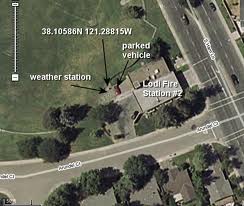
Fortunately, Google Maps provides a partial solution. If you type in the property address into Google Maps and then click on the Satellite button in the upper-right-hand corner of the map, you can see an aerial view of the property. This allows you to see if the property is located in the Boonies or in a thriving commercial area. You can use the wheel on your mouse to zoom in on the property from the sky. You can send your investors or potential clients a link to the satellite image of the property by clicking on the Link button, directly above the upper-right-hand corner of the satellite image. Just cut and paste that link right into your presentation.
 To see a street level picture of the subject property, look at the column to the left of the map. If the property is located in a major city, you will often see a street-level picture of the property. (By the way, never trust Google to point you to the exact building because the addresses are OFTEN wrong.) To see up and down the street, to get a feel for the neighborhood, click on the "More" hyperlink directly below the street-level picture of the property. Then click on the choice, "Street View".
You can also create a link to this street view of the property by clicking on the Link button, directly above the upper-right-hand corner of the street view image. Here is such a link. (Please allow it 20 seconds to load.)
Be sure to take a moment to play with this. If you move your cursor around, you can enjoy a 360 degree view of the property and the neighborhood. These are wonderful tools. Reminder to myself: Be sure to use them!
Are you a potential commercial borrower? You should download our important, free, whitepaper, How to Close a Commercial Loan During the Great Commercial Lending Drought.
Are you a mortgage broker? Download our free Commercial Loan Placement Kit that includes a list of 200 hungry commercial lenders, a Commercial Loan Placement Checklist, an important whitepaper entitled, How to Place a Commercial Loan When Banks Are Too Terrified to Lend, and our webinar on Structured Finance. This kit is free!
Are you commercial borrower? Wish you too could get a copy of this free list of 200 commercial lenders?
Are you an accredited investor? If so, what are you doing with your IRA? Accredited investors are earning 11% to 13% in first trust deed investments.
Do you need a commercial loan right now? You can submit your commercial loan to 750 different commercial lenders in just four minutes using CommercialMortgage.com. And this commercial mortgage portal is free!
 Better yet, the map was a satellite view of the land. By moving the roller on my mouse, I was able to look closer and closer at the land. What I found was interesting. The land was right on a major thoroughfare. Sewer, water, and power was already available to the site. Most of the surrounding land was already improved. All of the surrounding buildings were modern and attractive, and the area looked reasonably affluent. Now I don't know if we are going to make a land loan during the Great Recession, but its fair to say that because the broker provided a link to a satellite view of the property, this land loan might actually have a chance.